General Proposed Plan


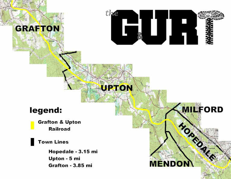
To the right is the overall map of the proposed Grafton & Upton Rail Trail project area. Consisting of approximately of 12 miles of the 15-plus mile shortline, the route follows a generally northwest- southeast course. Although the railroad line actually terminates in Milford, this proposal terminates the trail on Green(e) St in Hopedale.
Physical Facts:
| Bridges | 3 |
| Road Crossings | 18 |
| Overall Grade | .2% |
| Wooded Miles | 6.5 |
| Trail Length | 12-15.5 miles |
| Trail Width | 8 - 10 feet |
general plan map | elevation profile
Welcome to the proposed Grafton and Upton Rail-Trail plan. This page will lead you to details of the railroad through the communities of Hopedale, Upton, and Grafton Massachusetts. The pages contain photos and satellite images of the right-of-way as it currently exists (August 2002), conditions of road and river crossings, possible trail ideas, and concerns to be addressed in the project's development.
The plan is an ongoing process, one that literally takes years to develop and execute before the first visitor steps or rides onto its surface. If any of this is to become reality, it will take the combined efforts of hundreds of volunteers, generous contributors, aid and support of government agencies and our politicians, but most importantly it will take you. With a local population base of less than 27,000, the help of many people outside these communities is also critical. Please take a look and let us know what you think.
This proposal covers approximately 12 miles of the railroad's 15-plus miles of standard gauge track, passing through the quiet woods of the Upton State Forest and Hopedale Parklands, coming within a half mile of the historic centers of each of these three towns, and creates a new avenue for trade and tourism for the region. A very gentle right-of way, the route has negligible grades, allowing children and those with physical handicaps to easily traverse the route. Eventually this web proposal will cover all 15.5 miles.
Proposed with the plan are three major entry points, one for each town. At the southern end, in Hopedale, the depot house and yard would make for a great interpretation and visitor center for guests. On the grounds of the once mighty Draper Corporation, the yard has the area to accommodate plenty of vehicles, including trucks pulling horse trailers. The area includes the original depot (now being used by the Town), a rail car scale building, a small bridge over the Mill River, and the Grafton & Upton No. 2 car. In Upton, more specifically West Upton, there is a slightly smaller yard area, one that would be shared with current tenants in the nearby warehouses. it is easily reached off of Maple St, less than a half mile from the new Nipmuc (Mendon-Upton) Middle and High School and the Blackstone Valley Regional Technical High School. Although without a building, the location is currently the home to the No. 9 44-tonne diesel engine and a couple of other rail cars. to the north is the Grafton Center station, now just a concrete block building off of Upton St (Rte 140). The smallest of the three major entry points, Grafton seems to still have the potential to park at least a dozen cars in this business district. A great site for an interpretation/visitor center, the station is steps away from a conveniently located store and across the street from the Grafton Historical Society.
Click
anywhere on the Right-of-Way (yellow line) below to get to Town pages.
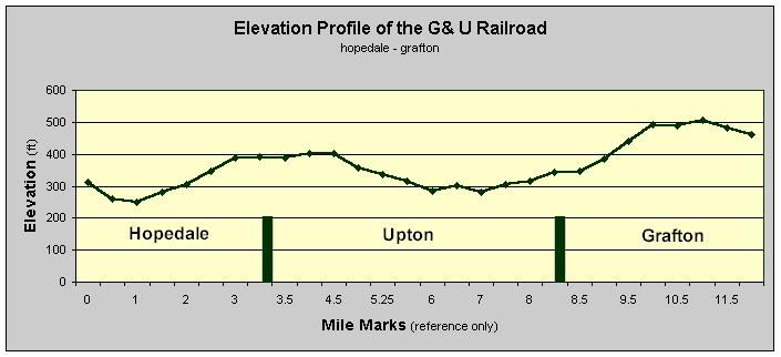
On the right you will find the elevation profile for the entire railroad from
the south (Green(e) St in Hopedale) to the north (Grafton
Center).
The overall net elevation gain from one end of the proposed trail to the other is 148 feet, or roughly .2%.
using a particular part of the trail as a comparison (see graph to right), the elevation gain from Mile Mark 7 (Upton Depot) to Mile Mark 10 (Old Upton rd, Grafton) is 210 feet, or an average slope of just 1.3%.